–Submitted by Matthew Lettington, originally published on explorington.com
Conuma Peak has been on my must-climb bucket list since I learned that it features a large arch in the side of the mountain–the largest on any of the mountains on the island. Conuma is the second peak in the Tlupana Range that I’ve climbed, and offers views of many of the larger peaks around it. This trip wasn’t the first time we put it on the schedule, but it’s the first time we put our feet on the ground at the mountain; each of our previous attempts was thwarted by rainstorms, snowstorms, or the enticement of more feasible trips. Our July 22 summit attempt featured blue skies with minimal haze, hot air, and a bounty of bugs that made us question our sanity.

Our research yielded route descriptions from a few successful summits of Conuma Peak, but each used a different approach. The one that appealed to us the most, the one we used, approaches from a spur off the H60 logging road that originates on the Head Bay Mainline, halfway between Tahsis and Gold River. From the end of the logging road, our route travelled up the east side of the ridge until it gains the south ridge, and then up to the main summit block. By my estimation, a successful summit of Conuma Peak has as much to do with the strength of your navigation abilities as it does your tolerance for the bushwhacking and bugs. From the map, it’s impossible to decipher the specific terrain; however, the title of my report reveals all the majesty that makes up the convoluted route to Conuma Peak.
Total Distance: 8.5 km
Starting Elevation: 563 m
Maximum Elevation: 1479 m
Total Elevation Gain: 1028 m
Total Time: 9 hours, 10 minutes

Even though we started our hike around 7:30 am, the temperature was already approaching twenty degrees Celsius. We parked near 600 metres and jumped into a short stretch of logging slash, crossed into the dense old-growth, and waded through the thicket of bush; we crossed water channels and poked our way along the first of the easy bluffs to ~900 metres. Before we reached our second hour, two of the participants were so overwhelmed with the combination of heat, bush, scrambling, and bugs, that they left their segment of rope with us and called it a day.

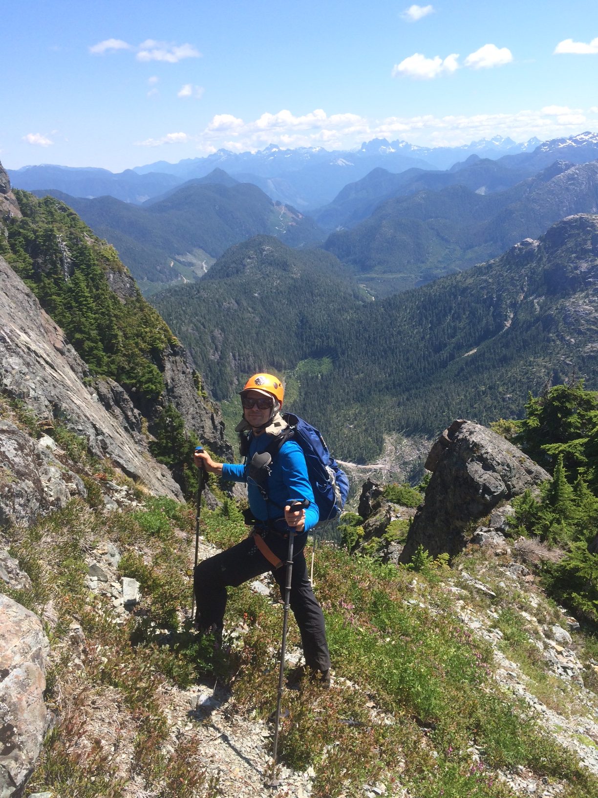
It was two and half hours from the car and another series of scrambles up bushy gullies before we crested out on the aesthetic south ridge (~1120 meters). We had only covered 2.5 kilometres and 550 metres elevation gain from the car! The ridge is the reprieve that kept us sane; it’s as beautiful a ridge as any I’ve seen on Vancouver Island. Of course, my perspective is skewed because of the grotesque nature of what came before and after, but for the short while we followed it, we enjoyed taking in the sights of the surrounding peaks and the Tahsis inlet. Then all too quickly, we were once again rowing through the bush.
We finally reached the base of the summit block (~1200 metres) at about 10:45 am. Conuma Peak’s impressive form rose high in front of us: we could see faces of rock and benches of thick fir and hemlock decorating it. When we looked back in the direction we came, we spotted the Jeep on the logging road and we could see our partners just starting their drive off the mountain. There was nothing left to do but tackle the maze of gullies and bush on our way to the final obstacle: the fourth class (maybe low-fifth) stretch of rock just below the summit.

It’s this section we gave the most consideration to in our planning. We knew that it was going to be a scramble, and it didn’t disappoint. We ascended one at a time, and each of us sent more than one rock down the chute. The route is obvious, but eventually, I was faced with an option of going to the right into the bush, or to the left along a smooth rock shelf with extreme exposure. I took the left. Once we were past the scramble, we clamoured over the choss pile that makes up the summit (1481m) to reach the cairn. Or at least, that was the plan– I was damn near carried off by a hundred thousand flying ants. They were all determined to stand on top of my helmet, the new highest point on the mountain.
Despite the onslaught of flying insects, Brook and I took our time on the summit to eat lunch (yes, with the bugs) and point out the peaks we could identify. Phil couldn’t tolerate the bugs – for some reason, they kept getting under his shirt – so he took his lunch lower down. After a suitably long lunch in the noonday sun, we took note that the temperature was rising closer to thirty degrees, and decided that it was time to retreat to the car.
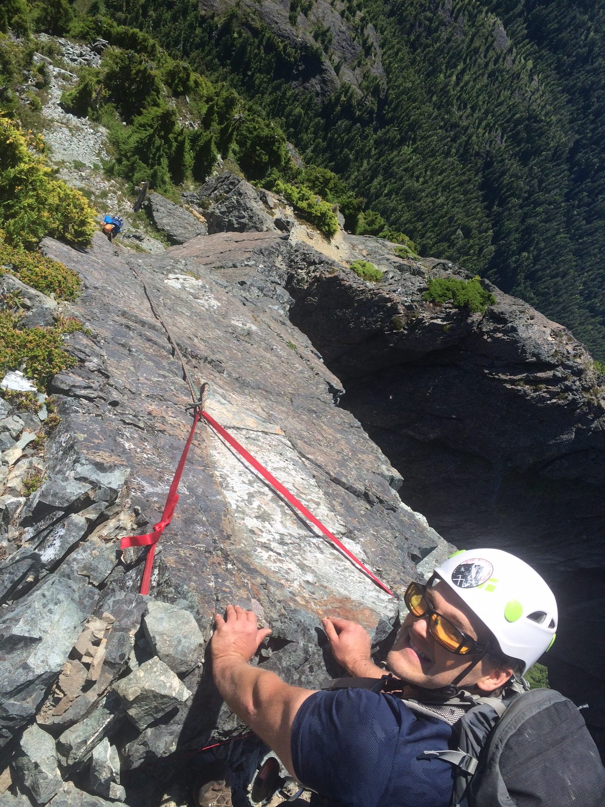
We opted to rappel down the rock to the easier terrain below. Now, it’s probable that someone with more stomach for exposure will have no problem scrambling down the rock, but since I don’t, and since I carried two 30-metre 8mm ropes for just this occasion, we used them. A single 40-metre rope would be enough to get down the worst of the terrain; the pair of thirties took us right down to the easiest area.
The fun of returning to the car was a whole new adventure, as the bush had swallowed our approach path. It was rare for us to find footprints through the bush, and in many spots, we couldn’t see more than six metres ahead. The scramble down the bluffs sometimes felt more like sliding down a tree. In any event, our return to the car took nearly as long as the approach to the mountain.

Was the juice worth the squeeze, as Phil would ask? Nope. Although the arch was an amazing feature to see, I had little more than a passing appreciation for it. Perhaps if our approach to the summit included passing through the arch, I’d be more jazzed about it, but all the same I’m glad that we didn’t use that approach; as we stood admiring the arch, we could hear spontaneous slides happening in the gully leading up to it.
If you attempt this peak, stop an hour into the trip and do a quick assessment of your situation. If you already feel like the bush is getting to be too much, cut your losses; get the heck out of there. If you’re relying on the hope that the bush is going to get better? It doesn’t. Although there is one amazing stretch along the south ridge that puts any alpine meadow to shame, the reality of the bush-covered bluffs, head-high blueberry, azalea, and willow, and hidden micro-terrain makes the trip to Conuma Peak one for my ever-changing Top Ten Bushwhack List.