–submitted by Goody Niosi; originally published on goodynoisi.com
It’s hard to believe – but here it is, February 2 (Groundhog Day!) and I just went on my first snowshoe trip of the season.

Living the best adventure life, since 1958

–submitted by Goody Niosi; originally published on goodynoisi.com
It’s hard to believe – but here it is, February 2 (Groundhog Day!) and I just went on my first snowshoe trip of the season.
It was late January. I’d been signed up for a winter snowshoe ascent of Mt Becher with the Island Mountain Ramblers for a while, but the weather had not been easy to predict of late. In the end, it had to be postponed for a week, but with a forecast of light snow and afternoon clearing, the trip was a go for Groundhog Day. Well, I’m no meteorologist, but that sounded good to me. I’ve only seen that movie about twelve times by now!

As our trip leader John was later heard to say “In Saskatoon, you know, we never really worried about the groundhog seeing his shadow. Six more weeks of winter didn’t sound too bad at all!” But I digress, despite the torrential rains of the previous Friday, it was time for us to gear up and head for the hills!
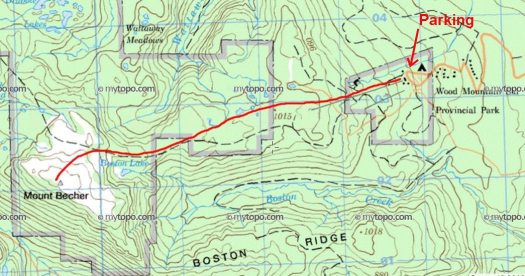
There were seven of us altogether: Fearless leader John, Mo, Karen, Sylvie, Goody, and I left Nanaimo at 730 am. We met Kristy on the mountain a little later on. As we drove up Highway 19, the sun and skies put on a bit of show, once we got north of Qualicum. I remember musing that it might just be the best light of the day, and that there had to be a storm behind it. Sure enough, when we reached the turnoff to Piercy Road, it had begun to snow lightly, and by the time we’d parked near the site of the old Forbidden Lodge, it was snowing harder and the wind had picked up considerably.
Continue reading “Mount Becher: ONE DAY INSIDE A SNOW GLOBE”

November 3, 2019
~ submitted by Mary Hof
On Sunday November 3, we had 11 hikers in total for the Mt Tzouhalem walk. Some were Ramblers and some were from the Cowichan Hikers.


We did it! We finally summited Mook Peak! Sure, it may have taken seven scheduled attempts, but we only set foot on the mountain twice. So often it appeared on the schedule, that it became a running joke between my hiking buddies and I. However, it was on the second attempt that we reached the summit.

Continue reading “Mook Peak, Or What Happens When You Go Biking With Phil”

October 27, 2019
~ submitted by Matthew Lettington
It was a horrible day for a club meeting. The sun was shining, birds singing, and a light breeze chilled the air to keep us from overheating.


Our group of seven spent a little over three hours exploring the first two ridges. By the time we arrived back at the parking lot, we had completed a 10.5 km loop with just about 400 meters elevation gain.


It was a perfect pre-meeting hike!

The Mount Benson Project continues to roll along. During the summer, we spent our time diverting water and shoring up the eroding bank. Since then, we have been reluctant to do any work that relies on the integrity of the work previously done. When the fall rains arrived, we examined the results of the work, and it appears that most of the water is being diverted off the trail. Though there is still more work to be done in this area, we are ready to move into some other areas of work.

On Wednesday, October 30, Dustin and Matthew loaded their backpacks and set out with adhesive, rebar, and hammer drill do work that added steps in a few key places within our section.

October 5, 2019
~ submitted by Christine Rivers
12 people enjoyed a mellow rambling hike to Mt. Drabble. The access was from 8km of logging road, off the second chain up area on the Mt. Washington road.


–submitted by Matthew Lettington
The hike to Green Mountain is always popular. Before the trip, I was turning way interested members as I already had 18 participants and a healthy waitlist. But as the forecast turned, participants started cancelling. By the time the day arrived, we were left with just seven hikers.


September 28, 2019
~ submitted by Matthew Lettington
On Saturday, October 28th, I led a group of 9 –including a 13-month-old—to the summit of Mount Apps. The sun may have been shining but that did not offer much reprieve from the biting cold and bitter wind.
Continue reading “Mount Apps from Buckley Bay Side”
Our late September trip to Pinder Peak was fantastic! The combination of a dry, cool day on a snow-free route filled with plenty of alpine berries reminded me why I (sometimes) love fall hiking! This trip was very different from my first trip to Pinder Peak.

If you’ve ever driven along by Atluk Lake, you’ve probably spotted the Pinder massif out your window. It rises from the wooded shores of the lake as a rocky tower that begs the mountaineer to climb it. The summit massif is marked by two prominent features, either of which is a worthy objective, though the subpeak is probably more of a challenge.

Total Distance: 14.0 km
Starting Elevation: 360 m
Maximum Elevation: 1550 m
Total Elevation Gain: 1223 m
Total Time: 7 hours
