What a difference a year makes! Last year when we hiked this trail, we saw nary a soul past Mount Albert Edward, but this year we met more than 20 others. One big group of about 20, a group of 3, a solo man and his dog, and two runners completing it in a day. The trail is also much better defined than it was just last year – a well-worn tread with many cairns leads the way. Although it is popular and pleasant, it’s far from a “walk in the park,” as over it’s 30 km it gains 2150 m and loses 3000 m. Lots of ups and downs! Since we started from Mt. Washington’s Raven Lodge with an elevation of 1100 m., we had an overall elevation loss of 850 m.
We started off with a stroll through Paradise Meadows
In the fall I posted a July trip to the Hinde. Greg Deabler offered to co-lead, which made the thing possible. Even with that much lead time, and even if Covid hadn’t interrupted hiking, I’d have trouble preparing to lead that serious a trip. Later a suggestion was made to change the plan to a traverse. John Young would lead a traverse from Elk River to Buttle Lake, ascending the Hinde along the way, and our group would do the same in the other direction. We conferred with those who were down for the trip that was originally planned and the decision was a “go”.
As it turned out, we didn’t complete our objectives but it was a great time in the mountains.
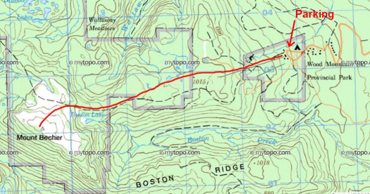
It was late January. I’d been signed up for a winter snowshoe ascent of Mt Becher with the Island Mountain Ramblers for a while, but the weather had not been easy to predict of late. In the end, it had to be postponed for a week, but with a forecast of light snow and afternoon clearing, the trip was a go for Groundhog Day. Well, I’m no meteorologist, but that sounded good to me. I’ve only seen that movie about twelve times by now!
It’s Ground Hog Day! To get the real flavour of this film, naturally, you have to watch it more than once!
As our trip leader John was later heard to say “In Saskatoon, you know, we never really worried about the groundhog seeing his shadow. Six more weeks of winter didn’t sound too bad at all!” But I digress, despite the torrential rains of the previous Friday, it was time for us to gear up and head for the hills!
Our route to the summit of Mt Becher
There were seven of us altogether: Fearless leader John, Mo, Karen, Sylvie, Goody, and I left Nanaimo at 730 am. We met Kristy on the mountain a little later on. As we drove up Highway 19, the sun and skies put on a bit of show, once we got north of Qualicum. I remember musing that it might just be the best light of the day, and that there had to be a storm behind it. Sure enough, when we reached the turnoff to Piercy Road, it had begun to snow lightly, and by the time we’d parked near the site of the old Forbidden Lodge, it was snowing harder and the wind had picked up considerably.
I’m a prisoner to my work schedule, and my summer vacation kicks off in the final weekend of June. However, since meeting Phil, I’ve come to participate in an annual pre-summer trip known as the Birthday Hike. This annual prelude-to-summer trip has brought us to some of the best places on Vancouver Island.
Wolf Mountain
For two days, starting June 22, 2019, we set our sights on the three peaks which rise high along the ridge, on the west side of the Elk River Trail. The ridge is among the best Island Alpine I’ve had the pleasure of hiking; its near-pristine nature is protected by the awful bushwhack of Butterwort Creek on one end and a gnarly few steps on the other. It’s the type of terrain that is only visited by the crazy few who would seek out these diminutive objectives over the many giants of the Elk River Valley.
Total Distance 28.6 km
Starting Elevation: 312 m
Maximum Elevation: 1826 m
Total Elevation Gain: 2421 m
My summers are hectic. I pack my days full of hiking in the mountains and coasts of the island. Often, I’m thinking about what to pack on my next trip while I’m unpacking my gear from a trip I’ve just finished. So come September, I’m ready to head back to work and the normalcy of weekly routines that it brings. But not before I squeeze in one last hurrah, on Labour Day. This year, we picked Marble Meadows as the destination for the weekend, and it didn’t disappoint. It was just what I needed after a summer of rained-out trips and the loss of a friend on a mountaineering trip.
through the foggy morraine.
Marble Meadows is a unique treasure within the boundary of Strathcona Provincial Park. But before you start shouting, “Uh, Matthew, there are many treasures in the park!”, let me qualify my point. It’s one of the few places you can stand on the top of a mountain and see exclusively unlogged landscapes, turquoise lakes, and the many types of rock found on the island. It’s a backcountry destination well-known by hikers and fossil-hunters for its rolling terrain, well-booted track, and the millions of fossils visible on the surface of the exposed limestone. You get the point: Marble Meadows is worth a special note.
Once you’ve done enough hiking on Vancouver Island, you will realize that most of the great hiking requires that you drive down a section of industrial gravel road. And that’s if you’re lucky; a good number of these places require walking stretches of road as well. Mount Mitchell is one of those.
The summit ridge on our approach to Mount Mitchell
Located along the Strathcona Provincial Park boundary, between the Norm Creek Valley and the south arm of the Oyster River Valley, this rocky feature creates a jagged protrusion of that boundary to include the area above 1200 metres into the Park. Below that, the terrain is stripped bare, and roads are visible throughout the surrounding valleys.
The long road through the valley to Mount Mitchell
Aside from the tragedy of the lost forest, the roads give fast access to the start of our route. In previous years when the gates were open, Mount Mitchell was considered a daytrip. In those days you could access the route either via the Oyster River gates off Highway 19, or from the Boliden-Westmin Road along the Buttle and Park mainlines. However, times change, and so do permissions and road conditions.
Northwest Ridge Approach to Mount Mitchell
Total Distance: 44.9 km
Starting Elevation: 232 m
Maximum Elevation: 1842 m
Total Elevation gain: 2548 m
On July 1st, two friends and I made a successful, though gruelling, summit of Crown Mountain inside Strathcona Park. The story of this day-trip is part of a much longer saga that starts with a failed summit attempt on Mount Colonel Foster.
A view down the Crowned Creek Valley from the highpoint on the north ridge
Getting up at 3:00 am isn’t my favourite way to spend a Sunday, but I do it week after week. I head outside, driven by my Island Alpine Quest, the goal of summiting more than 250 peaks. In doing so, I find myself hiking in some seldom-visited locations on Vancouver Island. Why do I do it? I’m the type of person who needs a goal to stay interested. There are factors that help smooth the rough early morning starts, like those fleeting moments of looking through old-growth forest or picking my way along a craggy ridge. But occasionally, the quest takes me to a place that I’ll never return – one worth skipping. Strata Mountain is in this category.
It’s not that the mountain is out of the way; after all, it’s in the heart of one of the most popular regions of Strathcona Park. And it’s not that it doesn’t have anything to offer; the high ridge tops out over 1400 metres, with an easy walking alpine ridge that has great views of many nearby peaks, including Mount Albert-Edward and Mount Adrian. But because the area is overused, and because there are many other nearby peaks that offer a more dramatic and aesthetic ascent, it’s just not worth the effort – except maybe as a side trip.
Nevertheless, it’s on the list, and Strata Mountain demanded my attention. On March 4th, 2018, I led a group of six Island Mountain Ramblers on a winter trip to the summit of Strata Mountain. It was a near-perfect day for the long trip across Forbidden Plateau, with clear skies that persisted through the morning, and a well-packed boot track that allowed for a quicker-than-normal pace.