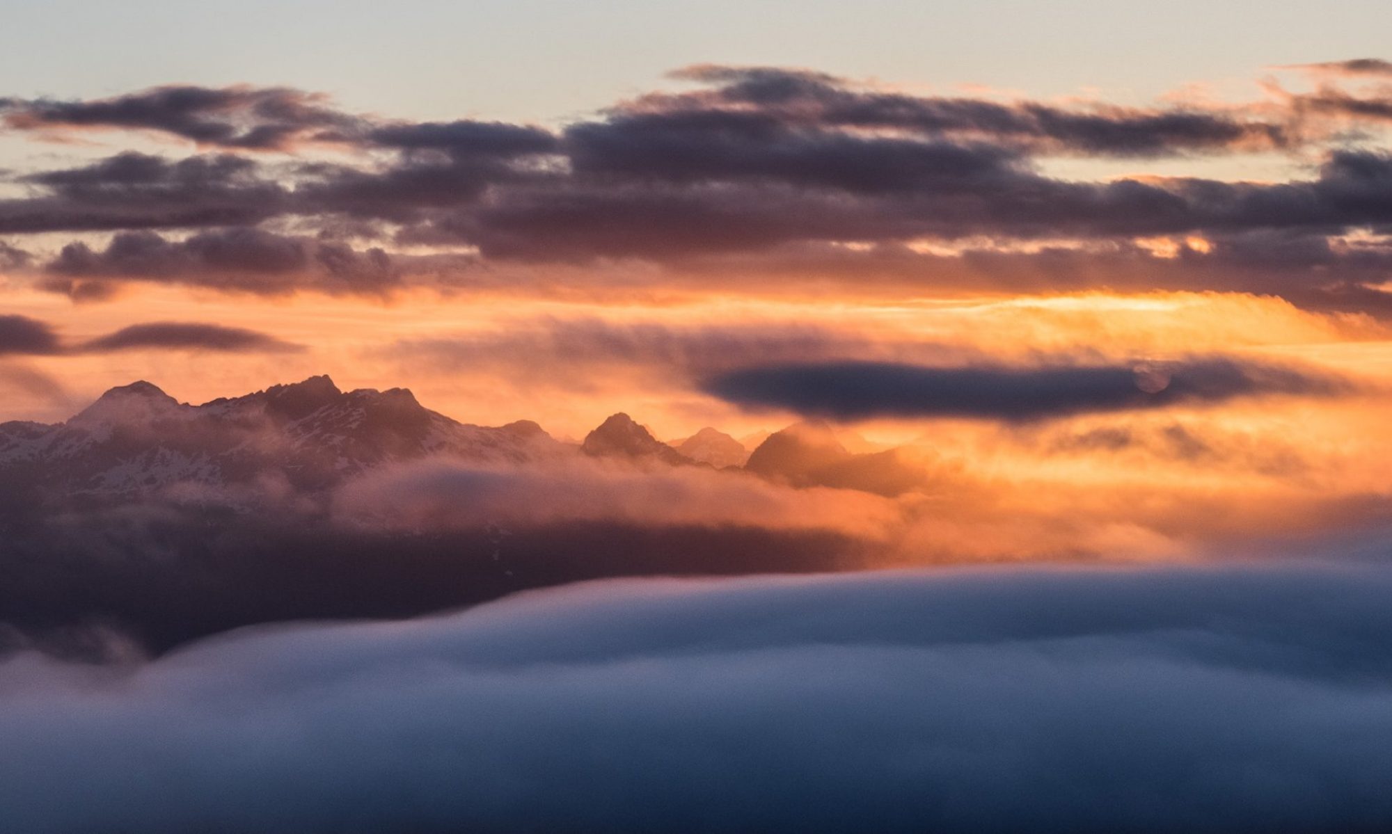
With trip planning spanning several months, complete with no shortage of shenanigans with the BC Parks reservation system, and the usual last-minute evolution of attendees, the trip date arrived. As an added bonus feature, we had an up to date weather forecast that suggested a “wee bit” of rain and some snow accumulations below the summit elevation, which cast some doubt on the potential for a summit as well as on the state of mind of those hardy hikers who stuck to the plan.
The transition between summer and fall was exceptionally rapid this year. After months of hot, dry weather, a cold front rolled in and brought temperatures below ten degrees and a deluge of rain that seemed to last for weeks. Even my five-year-old son noticed the change: “Dad, is it fall now?” Apparently so.
For me, the seasonal transition marks a time to reflect on my summer of accomplishments and disappointments, and to set new goals! New goals give me something to look forward to during the upcoming winter and help me plan out the next summer (I’ve already planned more than twenty days of trips for summer 2019). Between Phil and me, we have a lengthy list of multi-day adventures that we have been putting off, and this is the year to do them.
Phil on the summit ridge– it looks far!
Part of the planning for these trips is observing the inspiration that comes from reviewing the accomplishments of my online friends, via social media feeds. This summer, the algorithms inundated me with many stories about canyoneering. But, because I’m still only halfway through my Island Alpine Quest –a massive list of peaks– I didn’t dare dream too deeply, because I am committed to my current obsession. Perhaps this is why I never imagined finding myself in a steep-walled canyon, and I certainly never expected that experience to come on the descent of Mount Leighton, but that’s precisely what happened.
Total Distance: 11.3 km
Starting Elevation: 363 m
Maximum Elevation: 1409 m
Total Elevation Gain: 1086 m
Total Time: 7 hours, 41 minutes
Congratulations are in order for Clarke Gourlay. He has completed more than 15 of the 20 Lifetime Climbing Objectives and has earned the Silver Award. Clarke will receive his award at the Fall meeting.
Beautiful area. Easy canoe voyage across the lake, nice open switch backs to the alpine and easy terrain spotted with turquoise lakes in Marble Meadows. Complete with Karst sinkholes, caves and fossils galore. Easy camping, good water (even after this very dry summer) and tall, but not difficult, mountains. The whole group successfully climbed both peaks we set out for, and five of us added Marble Peak as an extra (a bit spicy and exposed). Spent the one rainy evening/night in Wheaton Hut luxury. Could have easily done the trip beginning Saturday morning early (we started Friday afternoon). Wind at our backs both ways across the lake!
Congratulations are in order for Phil Jackson. Phil has completed 10 of the 20 Lifetime Climbing Objectives and has earned the Bronze Award. Phil will receive his award at the Fall meeting.
When I was new to mountaineering, I was often intimidated when I listened to experienced mountaineers talk. They always seemed to know where they were and could easily identify the peaks they could see all around them, when to me it just looked like a sea of peaks. Further, they would talk about the names of places and trails as though they were commonplace. Features like the Augerpoint Traverse, and names like Mount Albert-Edward, were just two of the many names everyone (other than me) seemed to know. It was overwhelming! Although I was interested in learning about the places, names, and locations, I couldn’t imagine a time when I’d be able to identify them all.
Fast forward eight years, and today I can identify the shapes of many peaks amongst the sea. A big part of that is visiting a wide range of places, though I still struggle when I visit a new area. On top of being able to identify places, I’ve also met many of my hiking goals. Since I started hiking, I’ve hiked many of the most common access points to Strathcona Park, and even managed to hike one of those routes I heard about long ago: the Augerpoint Traverse (sometimes referred to as the Mount Washington to Buttle Lake Traverse).
Horizontal Distance: 47.8 km
Average Speed: 0.5 km/h
Starting Elevation: 291 m
Maximum Elevation: 2092 m
Total Elevation Gain: 3064 m
Route planning is among the most important parts of trip planning. It influences equipment choices, time estimates, and helps one visualize the role environmental conditions will play on the expected terrain. Sometimes route planning is easy; the most popular routes have trails, booted track, well-documented maps, GPS tracks, and dozens of trip reports. And sometimes, it’s not so easy – for example, my trip to Watchtower Peak in the Sutton Range. A key difference between easy and challenging routes is the beta available.
Watchtower Peak wasn’t our primary objective for the weekend and so Phil and I had the one-paragraph description in Island Alpine (2002) to rely on. It boils down to three points: Gain the ridge; Follow the ridge; Avoid troubles on the left side. A key part of using any beta is interpreting the information and its validity. First, you have to the question if the author is describing the route based on their first-hand experience and what their individual experience level is; Or, if it isn’t first-hand knowledge how reliable was their source. Assuming that you trust the resource, you have the job of interpreting the route description and reconciling it to the terrain. This experience might be lived out while neck-deep in some mountain hemlock looking for the edge of a cliff you may or may not be standing on, or even whilst dangling into a gully trying to decide if the route “goes”.
Warden and Victoria in the background
On the other side of the coin, there’s the trick of writing a trip report. It’s always challenging for me to parse the information in a way that will be meaningful for those who hope to do a trip of their own. A big fault for some of my reports is their depth of detail; giving too many details can be just as harmful –maybe more, even—as giving a report with too little information. Yet, here we are with another trip report. Hopefully I can avoid being both too sparse and too detailed.
Seems to be a trend but 06:00 hrs on 19 August found five hikers loitering about the north Nanaimo Starbucks……mostly because they are the only place open at that time of day that is not Tim Hortons. A quick stop in Whiskey Creek to gather the other three people and onward we went, arriving at the trail head right about 08:20. The smoke haze was, at this point in the day, still relatively high and thin.
My fifth trip on the Nootka Island Trail off the west coast of Vancouver Island didn’t disappoint. In fact, I might have enjoyed it more than ever. It was more crowded than before–we saw several other groups of hikers, one even bigger than our group of nine. But, still not nearly as busy as other coastal hikes such as Cape Scott or the West Coast Trail, due in large part to the remoteness, accessible only by water taxi or float plane.
As the organizer of our trip, I opted for the water taxi transport return from Tahsis. It’s a lot cheaper than flying (especially when we had nine people in our group), and scenic, although on the day we set out, it was drizzling and rough, so not as enjoyable as when I last did it two years ago. With the boat ride option we had an extra three km to walk, too, at low tide across picturesque mudflats, making the trail about 40 km long altogether.
The trail is not on protected land, and is only sporadically maintained by volunteers, although in places you’d never know it, with huge fallen trees to clamber over and salal to stagger through. For me, though, this is part of the attraction–the ruggedness of it. And the variety of the trail is arguably unsurpassed — from lush old growth rainforest to swampy headlands, sandy beaches to boulder fields, the wonders never cease.
Thanks to my fellow hikers for making this a most enjoyable excursion!
On Saturday, July 28 a group of 6 Ramblers headed up to do the Mt. Curran-Squarehead-Joan traverse, just north of Horne Lake. We drove up the Cook Creek Service Road for almost 15 km, and then up the rough logging road. It was a hot day, a scorcher, so the six of us were grateful to be able to drive up the jarring road, even if it was snail paced. We started hiking at nine a.m., and didn’t finish until 6:30; a long day in the hot sun. But the vistas and the profusion of blooms made up for it, as well as the good-spirited hikers.