A winter route up Big Den turns unseasonably warm

–submitted by Matthew Lettington, read it on his blog

This year, winter on the West Coast has been full of surprises, though this may only have been noticed by those who venture outdoors. Winter keeps serving up a huge variety of weather! We’ve seen temperatures at sea level that dip below negative ten for so long that lakes in Nanaimo have frozen hard enough to walk on, snow piled up on the roadside and yards for more than a month, blizzards in the mountains, and now, temperatures in the high alpine that are reaching into the low teens. On our February 13th adventure up Big Den Mountain, the unseasonably warm conditions forced us to turn back.

Big Den Mountain , Strathcona Park GPS Route
Big Den Mountain, Strathcona Park GPS Route

Total Distance: 8.7 km
Starting Elevation: 109 m
Maximum Elevation: 1470 m
Total Elevation Gain: 1377 m
Total Time: 7h 15 m


Continue reading “A winter route up Big Den turns unseasonably warm”

First Family/Novice Snowshoe of 2016

–submitted by Matthew Lettington

The forecast held true for our scheduled Family/Novice snowshoe trip for the winter 2016/2017 season. The skies were darkened by overcast skies air temperature hovered just below freezing, and there was hardly any falling snow. overcast skies and the air was slightly below zero, on the Island Mountain Ramblers first Family/Novice snowshoe trip of the 2016/2017 winter.

helen-makenzie-snowshoe-screen-0275

Continue reading “First Family/Novice Snowshoe of 2016”

Crest Mountain

–submitted by Lisa Hanlon
Gorgeous day for a hike up Crest mountain. We met at the trailhead at 8:30am on Saturday, September 10th.. After a slog up the switchbacks through beautiful old growth forest, we were rewarded with the first views of King’s Peak. Once we emerged from the forest into the sunny alpine, we stopped for a snack break.

Continue reading “Crest Mountain”

Horseshoe Mountain: The Journey is the Destination

-submitted by Matthew Lettington: Read the original post on his blog

Everyone has a favourite hike. For some, that hike may be a well-travelled location, such as the Cape Scott Trail, or a route past Lake Helen Mackenzie. For others, favourite routes are more private, with information held close by those in-the-know; secret spots where not many people venture. Assuredly, Horseshoe Mountain belongs in the second category, as one of Vancouver Island’s best-kept secrets.

Horseshoe Mountain has views to rival many of the better-known routes. With easy Class 2 hiking through old-growth forest, and a final approach along a broad, high-elevation alpine ridge to the 1742-metre summit, it’s surprising that Horseshoe Mountain isn’t more well-known. The reason is simple, and the title of this post alludes to it: accessing the trailhead is a pain in the rump!

>

Horizontal Distance 5.8 km
Starting Elevation 1230 m
Maximum Elevation 1742 m
Total Elevation Gain 642 m
Total Time: 3h 45m

Continue reading “Horseshoe Mountain: The Journey is the Destination”

Mount Becher in the winter

–Submitted by Matthew Lettington, read the full trip report on his blog

Island Mountain Ramblers descending Mount Becher; Matthew Lettington
Coming around the mountain

Adventure is ephemeral. For many, a real sense of adventure comes in a novel experience, such as discovering a new place or a new activity. For me, adventure comes in taking chances. 

On Sunday March 5th, the adventure was in risking poor weather on a hike up Mount Becher, and navigating in questionable conditions. Mount Becher is a common location for those seeking easy access to a backcountry experience. Depending on the season and conditions, it offers hiking, snowshoeing, backcountry skiing, ice climbing, ridge walking, and more. On occasion, I’ve even found snowmobilers using the old ski runs!

 The trailhead is the old Forbidden Plateau ski resort, also referred to as Wood Mountain. From Highway 19, follow Piercy Road to Forbidden Plateau Road (less than five minutes down the road). Forbidden Plateau Road is usually in good condition, often accessible by city car, because it’s plowed in the winter. This explains why, on a sunny day, I frequently find 15 or more vehicles parked in the lot.

Mount Becher GPS route and Map

Total Distance: 11.4 km
Starting Elevation: 690 m
Maximum Elevation: 1391 m
Total Elevation Gain: 770 m
Total time: 6 h 30 m

Upon arriving at the parking lot, we discovered that the recent snow that dumped 50cm on nearby Mount Washington had delivered only rain to the Forbidden Plateau area. It was almost bare; looking up the hill, I could see a lot of exposed rock and gravel leading up to the old shed. I wasn’t surprised, as winter is coming to a close. I abandoned the hope of testing my sled on some steeper terrain, and strapped the snowshoes onto my backpack.

–read the full trip report on his blog

Crest Mountain on a less than perfect day

–Submitted by Matthew Lettington
Read the full report on his blog…

An important part of planning any trip is having a Plan B, and sometimes a Plan C. There are a lot of factors that go into developing backup plans, but for me, one of the most important factors is geography: Plan B should be close to Plan A. On Sunday February 28th, we were scheduled to make a summit attempt on Horseshoe Mountain. After a long haul from Nanaimo toward Gold River, down Highway 28 and then an additional 20 kilometres of logging road, we were turned back by a pile of snow more than six feet high that blocked the logging road leading to the Horseshoe Mountain Trailhead. We wasted no time in making the decision to switch to our alternate objective, Crest Mountain.

Crest Mountain in Strathcona Park offers great easy hiking along a ridge with a great view
100 metres more to go to the summit ridge but the view was worth it

Late last year, but early in the winter snowshoeing season, we had a failed summit attempt on this peak. At the time, the snow depth was up to our shoulders, and we failed to find the all-important gully that leads to the lake at the top of the summit ridge. Today, we would fare much better.

Read the full report on his blog…

February 27th Beginner Snowshoe Trip to Lake Helen Mackenzie

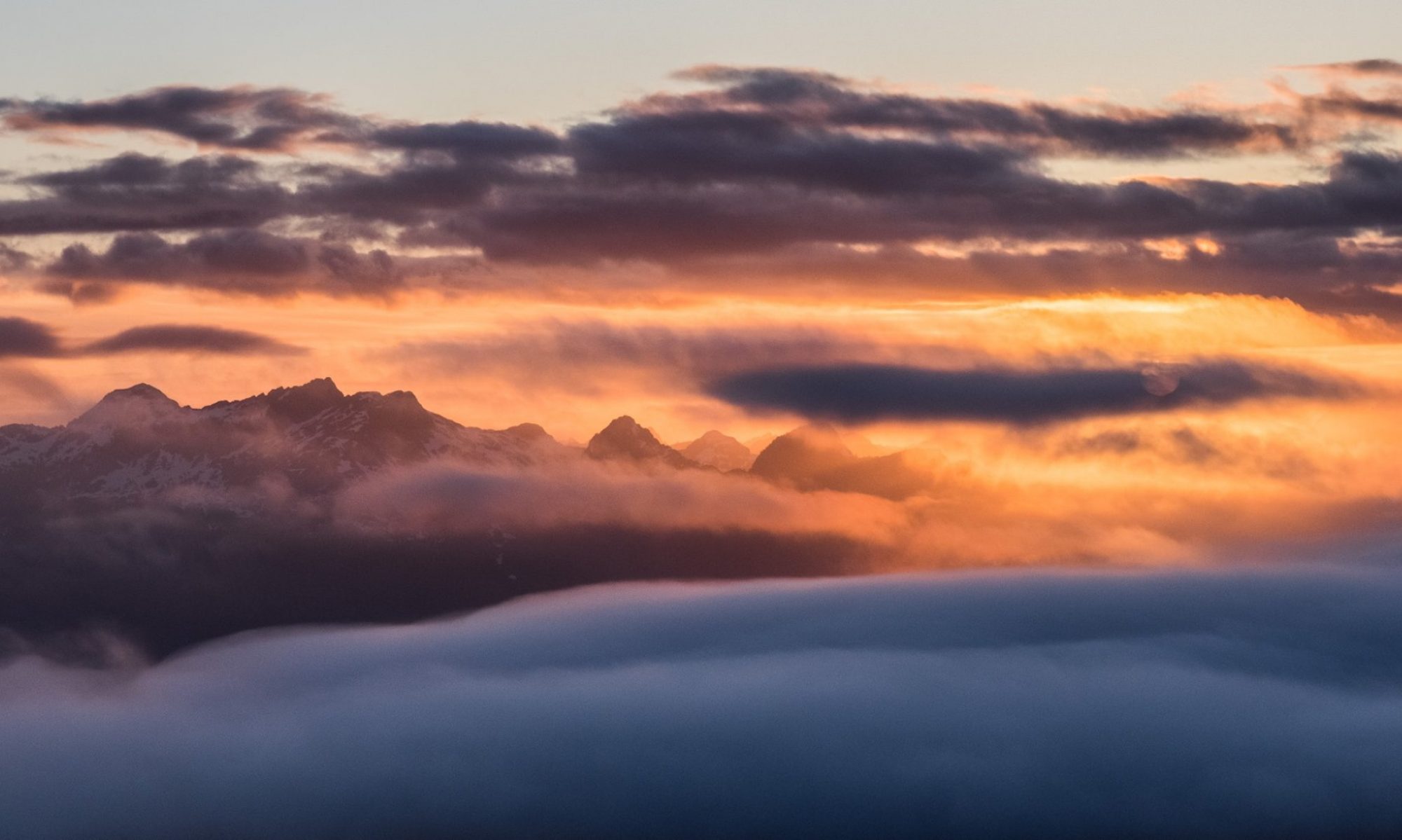
February 27th, 8 Island Mountain Ramblers gathered at Ravel Lodge to head out for an easy snowshoe to Lake Helen Mackenzie. We were expecting poor conditions; overcast, and possibly some rain. We got lucky! We found sun, even if it the sky was dotted with racing windblown clouds the view was spectacular.

Photograph by James Latham

image by Michael Paskevicius
It hasn’t snowed in quite a while in Paradise Meadows, probably it is more likely that it has rained. The snow was icy with a thick crust. Even as we made our way up to the lake, and at the lake, the snow was dense and supported our weight. Our biggest biggest issue was the icy trails, and disappearing snow. The snow covering the bridge before Helen Mackenzie is eroding, only a narrow fin remains. Mo unloaded Hemingway from the sled and carried him across in her arms. I hauled the empty sled across without incident. It’s better to be safe than sorry!

image by Michael Paskevicius

They icy trails offered a minor challenge. The pulk sled rode high on its vinyl runners. On traverses the sled slid sideways. At one point right off the trail, rolling, and ejecting Hemingway onto the snow!  He cried but he settled quickly after the jolt! The crusty snow transferred nothing onto him, so he was happy again shortly after loading him back into the sled. I think Hemingway’s main complaint is when the snow gets on his face and down his neck.

image by Michael Paskevicius

We made the lake in just over an hour, I was surprised at our speed. The hard packed conditions of the trail encouraged as speedy arrival. Because, we arrived so quickly we took our time to enjoy the wonderful sun, and eat our lunch. After feeding the birds and petting some dogs, we left walking across the lake on our way to Battleship Lake.

image by Michael Paskevicius

We arrived back at the parking lot shortly after 1 pm. Again I was surprised by our speed, but the conditions were idea for snowshoeing and the time/distance calculation fit with summer times. We hiked 8 kilometres, and hiked an accumulated elevation of just under 200 metres. Next time we will stop and smell the flowers, or take some pictures to really enjoy the sun! It was a short day but a gooder.


View full album, more than two dozen images!

Mount Allan Brooks Intermediate Snowshoe on Family Day Weekend

-submitted by Matthew Lettington
Read the full report on his blog: Boring Art, Boring Life

Making the most of a long weekend means different things to different people. For Family Day Weekend 2016, I jammed in a daytrip for each of the three days, including an overnight camp at a familiar trailhead in Seward. Don’t fret, though; I spent at least one of those days with my family! On the first day, we did a beginner snowshoe trip to Lake Helen Mackenzie. On Day Two, I led an intermediate snowshoe trip to Mount Allen Brooks. For the final adventure, we cranked up the intensity at Stowe Peak, in the Prince of Wales Range.

Island Mountain Ramblers walking through Paradise Meadows
The line of Ramblers snaking along

Our trip to Mount Allen Brooks started at the early hour of 6:00 am, as we headed up to Raven Lodge. The morning brought poor conditions: dark clouds cast a dim light on the landscape, a light rain was falling, and a stiff breeze passed through us all as we stood outfitting ourselves, signing waivers , and waiting for everyone to arrive.

 I started the day with minor trepidation. This was my third attempt of Mount Allan Brooks; the two failed attempts were in less favourable conditions, but on this day I was less than fresh, as my hips were bruised from hauling my son around in the pulk sled the day before. It’s not often that I start a hike fatigued from an effort the day before — unless a tent is involved. However, I had a good feeling; the day before, I had noted that there was a cut track all the way to and across Lake Helen Mackenzie. Beyond that…. we would have to discover!

Mount Allen Brooks GPS Route & Map Strathcona Park, Vancouver Island
Mount Allen Brooks GPS route & map

Total Distance:  14.9 km
Starting Elevation: 1066 m
Maximum Elevation: 663 m
Total Time:  7 hours

Read the full report on Matthew Lettington’s blog: Boring Art, Boring Life

Family Day Weekend, Beginner Snowshoe

–submitted by Matthew Lettington
Read the full report on his blog: Boring Art, Boring Life

Family Day Weekend has come and gone, and I’m happy to say that I made the most of it. I planned three trips, including an overnight camp at a familiar trailhead in Seward. Don’t fret: I spent at least one of those days with my family! The first day was a beginner snowshoe trip to Lake Helen Mackenzie; Day Two, an intermediate snowshoe trip to Mount Allen Brooks; and the third, a more challenging trip to Stowe Peak, in the Prince of Wales Range.

Island Mountain Ramblers, Snowshoe to Helen Mackenzie
everyone looking out for the littlest Rambler

On Saturday February 6th, eleven Island Mountain Ramblers headed out from Raven Lodge on an easy snowshoe trip to Lake Helen Mackenzie. Several guests joined us, including two of Kim’s long-time friends, Emhrys and Nichole.

Raven Lodge to Lake Helen Mackenzie snowshoe
Lake Helen Mackenzie Map with photographs

Total Distance: 6.8 km
Starting Elevation: 1068 m
Maximum Elevation: 1161 m
Total Elevation Gain: 178 m
Total Time: 4 hours 30 minutes

Mount Myra, a first attempt

–submitted by Matthew Lettington
Read the full report on his blog: Boring Art, Boring Life

Stonewalled, again! I’m getting tired of writing reports that end with a failed attempt on some peak or other. So far this winter we have been turned back on more than 4 different peaks! Mount Myra is the latest peak to turn us back and be added to the list.

Mount Myra in Strathcona Park
The long but quick road home. 

We expected good weather and we weren’t disappointed. Excellent visibility, cool temperatures, and light snow wouldn’t be the undoing of our attempt. An incredible accumulation of recent snow would accomplish that.

Mount Myra in Strathcona Park
Mount Myra Map and Photographs

Total Distance: 12.5 km
Starting Elevation: 331 m
Maximum Elevation: 1161 m
Total Elevation Gain: 926 m
Total Time: 8 hours

Read the full report on his blog: Boring Art, Boring Life