Simple Snowshoe around Lake Helen Mackenzie

–submitted by Matthew Lettington
Read the full report on his blog: Boring Art, Boring Life

Another beautiful day in the low alpine. On Saturday, January 30th, I led a small group of Island Mountain Ramblers, along with a special guest, on a trip through Paradise Meadows to Lake Helen Mackenzie and back. We had fine weather: a little sunshine, some light snow, and a clear view along our route.

Hiking Paradise Meadows in Strathcona Park, Battleship Loop

In late 2015, I built a pulk sled to use on my ski and snowshoe adventures. Its purpose is to carry gear and my little guy, Hemingway. Since building the sled I’ve made a number of modifications, attempting to improve performance. Hemi was in tow today as we made our way from Raven Lodge.

We left shortly after 10:00 am; we were in no hurry for this simple snowshoe to the lake and back. On our way to the lake, we followed the summer route from the lodge. Though the route is commonly traveled, the conditions vary. On this day, the route had icy patches with a few areas sloping off the booted track downhill. Unfortunately, the sled performed poorly in these short sections as I have yet to install stabilizing fins, or a skeg.

Helen Mackenzie – Battleship Lake route Map

Total distance: 8.4 km
Starting Elevation: 1072 m
Maximum Elevation: 1165 m
Total Elevation Gain: 214 m
Total Time: 4 hours

Read the full report on his blog: Boring Art, Boring Life

Touring Mount Allan Brooks’ Glade

–Submitted by Matthew Lettington

Read the full report on his blog, Boring Art, Boring Life

Last year I purchased some used alpine touring ski gear, but with the terrible winter I didn’t use it. This winter, however, has been kind to us. Lovers of winter sports rejoice! Everyone is dusting off their far-too-seldom-used gear to head into the backcountry.

Mount Allen Brooks, Skitourig Strathcona Park
John and Chris examining the route down

I planned an easy tour around Helen Mackenzie for Saturday, January 16th, intending to test out my gear. My boots needed some breaking in, and I needed to practice movement in walk mode with my skis. There would be plenty of practice, but we found more adventure than we originally intended.

Prepping at Raven Lodge
John and I traveled together and met Rod at Raven Lodge; he had bivyed overnight in Paradise Meadows. The sky was dark and the snow fell with the wind, blasting us in the face and pushing its way into the car when we opened the hatch. We gathered our gear and changed in the protection of Raven Lodge. As we dressed, we met up with a group of three more skiers from the ACCVI. Our groups had different agendas, but we were planning on travelling the same route. John, Rod, and I joined their trip up to the glades, the col between Mount Allan-Brooks and the Bump on the …..

Read the full report on his blog, Boring Art, Boring Life

Mount Drabble intermediate snowshoe

— Submitted by Matthew Lettington, read the full report on his blog Boring Art, Boring Life


A long time ago, when people were talking – for the first time – about a certain movie that took place in a galaxy far, far, away, there was an underutilized ski resort on a site which is now commonly referred to as “the old Forbidden Plateau ski hill”…
Bright and early on Sunday, January 10th, we were on the road, questing for adventure in Strathcona Park. Six of us made it to the trailhead for first light. The icy road and parking lot were plowed, making transit easy, but once we parked and exited, John’s truck slid a few inches. We took our first steps up to the proper snow of the old slopes at 8:00 am.

Hiking Mount Drabble, Strathcona Park
The gang rambling the rolling hills, approaching the summit of Mount Drabble
Mount Drabble Map and GPS route

Total Distance: 17.9
Starting Elevation: 713 m
Maximum Elevation: 1364 m
Elevation Gain: 1155 m
Time: 8 hours 15 min

We found winter! It was hiding at Crest Mountain

— Submited by Matthew Lettington. Read the full report on his blog, Boring Art, Boring Life

It’s been two long years but it’s finally here: winter! Last year, I had big aspirations for winter: snowshoeing, skiing, alpine ski touring, and winter mountaineering. Of course, winter never arrived. Like many other Vancouver Islanders, I have photographs taken on the summits of mountains that are bald! I remember a particular hike up 5040, when Phil and I sat on the summit sunning ourselves in shorts and t-shirts – in February. Even Cobalt Lake had only a thin crust of ice on it, and a few crazy girls were swimming in it! Regardless, winter is here now, and we found it in Strathcona Park.

Crest Mountain Trail
Ramblers snaking up the hill

Continuing through my long list of mountaineering ambitions, Crest Mountain was the goal for December 20th. By all accounts, it’s easy and commonly hiked. It features a well-developed and marked route with signs in a few key places, and the trailhead is on the side of the highway. The trail does have a few steep sections before attaining the summit ridge around 1400 metres, and then an ambling ridge walk to the main summit. However, meteorological conditions prevented us from achieving our goal.

Crest Mountain Map GPS Route
Crest Mountain Map

Total Distance: 8.4 km
Starting Elevation: 338 m
Maximum Elevation: 1216 m
Total Elevation Gain: 934 m
Total Time: 6 hours 15 minutes

Read the full report on his blog, Boring Art, Boring Life

Mount Phillips via Arnica Lake

I’m using Island Alpine as a benchmark of mountaineering achievement, a checklist of mountains to summit. It mostly leads me to exciting adventures which I approach with anticipation, but every so often I find a hike where my expectations are low. Setting out to hike Mount Phillips in Strathcona Park is an example. In August 2013, I hiked the lengthy Phillips Ridge to the peak of Vancouver Island, The Golden Hinde. I assumed I would be hiking a well-booted trail through open terrain to a summit that many people regularly visit. The day would blow my expectations out to the water.

Mount Phillips, Strathcona Park, Vancouver Island, Map and GPS Route

GPS route with photographs in place

Total Distance: 29 km
Starting Elevation: 350 m
Maximum Elevation: 1722 m
Elevation Gain: 1900 m
Total Time: 9.5 hours

 Our new hiking tradition seems to be setting out well before dawn. On Sunday, October 18th, we set out from Phil’s house at 5:30 am, and arrived at the trailhead near the Nystar Mine not too long after sunrise. On the drive in we were mired in dense fog, but temperatures were warm, around 12 degrees, even before dawn. We were in for a cracker of a day!

-Read the full report on Matthew Lettington’s Blog: Boring Art, Boring Life

Mt Albert Edward with Youth

 –Submitted by Bil Derby

26 – 28 September 2015

We all know Mt. Albert Edward, most of us have been there (some many times), and, for all arguments sake, it is an easy summit to tuck under our belts. It was my first island summit in 2005 and the one that sparked my interest in mountaineering and the alpine that burns strong today. This past weekend I had the pleasure of introducing four Royal Canadian Air Cadets (shameless plug for the Air cadet program) aged 14 – 17 to Mt. Albert Edward.

This trip was their second with me, the first being Flores Island, and was their first island summit. It was also the successful completion of their respective Bronze and Silver level expeditions within the Duke of Edinburgh’s Award program, the cadets having planned and executed the trip on their own with only my supervision and advice on risk management.

We started from Raven Lodge early afternoon on Saturday and found ourselves at Circlet Lake at 17:30 after poking along through Whiskey Meadows, taking a few detours to see things, and stopping a few times to deal with tender feet, adjust packs, and offer encouragement in the form of food……they are teenagers after all.

Sunday was an amazing bluebird alpine day, all sun……and wind. The ascent to the ridge reminded tired legs of yesterday’s exertion and hinted at the exertion yet to come but the view from the first alpine plateau was reward enough and spirits remained high.

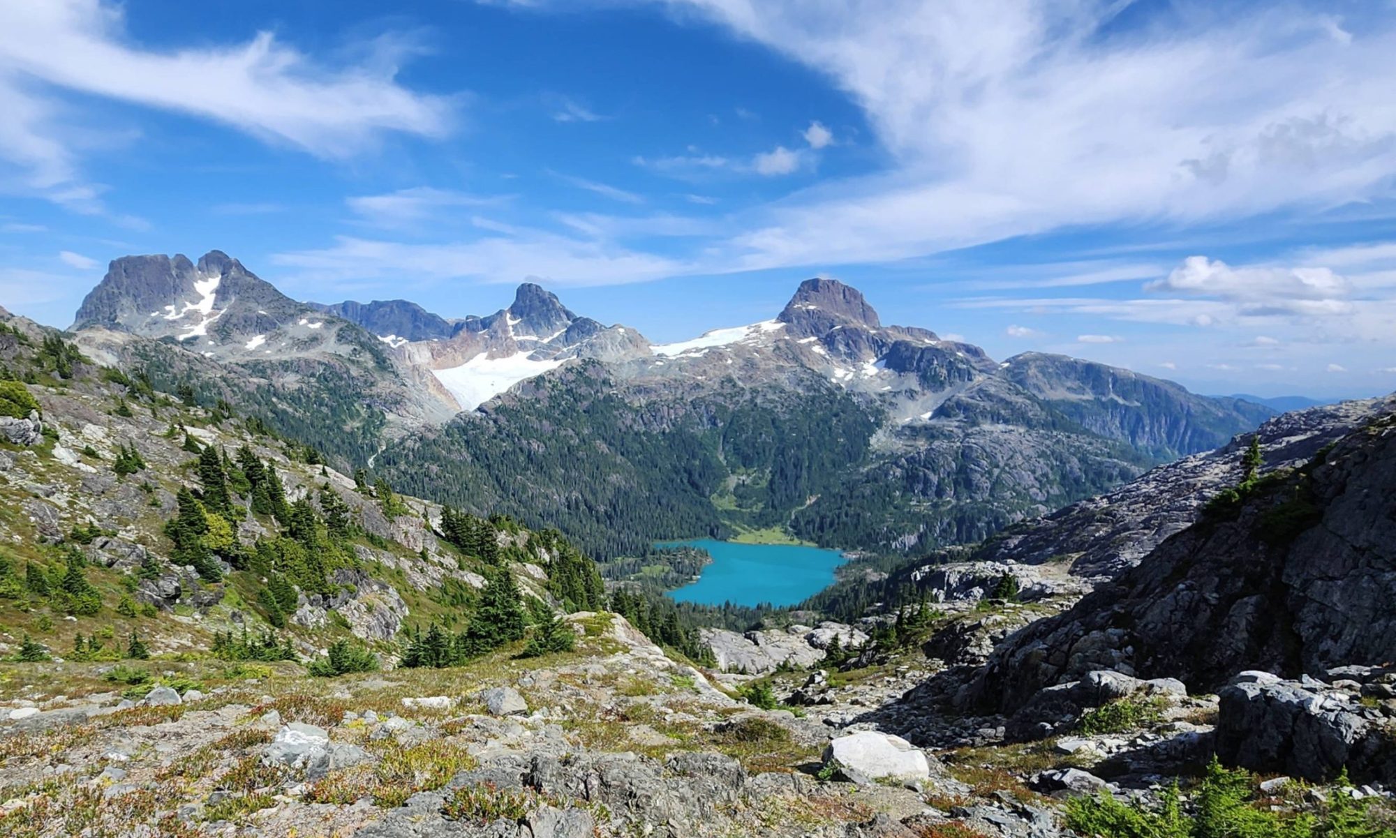
Reaching the main ridge line connecting Jutland and AE there was suddenly a clear understanding of the scale of the mountains.

Mount Albert Edward (left), Mount Regan (Right)

Lunch enroute, a bit of a snowball fight, and a long slug up the summit slope found us on top at lunch and notations made in the register. We were five of 17 to summit, not counting the five that were coming up as we were headed down.

Back at Circlet for supper and a debrief on the days experience and then, to my amazement, the teenagers went off to bed while the old guy stayed up and watched the stars drift by in a crystal clear sky.

Monday we came out via Murray Meadows, Kwai Lake, and the Battleship trail. Tired teenage legs conveyed tired teenage bodies relentlessly towards the truck….and food….did I mention they were teenagers.

All in all it was a fantastic trip with a fantastic group of kids. They enjoyed their trip and I enjoyed their enthusiasm, energy, and trust. Lessons were learned; I from them and them from me, and each of them came away with an little bit deeper understanding of their place in world, the value of wild places, and the accomplishment and confidence that comes from stepping out of their comfort zone.

Planning, in the warm light of accomplishment, is underway for their next adventure. Hopefully they humour me once again and let me tag along; it keeps the mind young when you can share time with youth.

Bil Derby
Captain
205 Collishaw RCACS (Nanaimo)
Canadian Cadet Organization

Cruikshank Canyon

— Submitted by John Young
The day turned out much better than we’d expected. It was raining on the
drive up, but we just had some light mist on the hike, and by the end of it,
the sun actually came out. Although the views weren’t there (couldn’t see
Cruikshank Canyon at all!), the fall colours were wonderful, and the many
mushrooms were dazzling. A lovely seven hour jaunt around Paradise!

Mount Regan, via the Lower Route

–Submitted by Matthew Lettington, 

Vancouver Island, home to forest giants and cold oceans is often overlooked for its alpine opportunities. A favourite feature of the high alpine is the chance to strap on crampons and walk the many pocket glaciers and snow fields. However, the changing environment means that glacier walking on Vancouver Island may have it’s days numbered. This year with the hot dry conditions, after a year of poor winter snow levels, the glacier ice melt is visible. I visited many mountains this summer and walked on a variety of these pocket glaciers, in all cases the blue ice was on the surface and melting away.

Hiking to Mount Regan
Mount Albert-Edward (left) and Mount Regan (Right)

September 13th, 2015 I was joined by Phil and two others on a day trip up Mount Regan. It’s Mount Albert-Edwards neglected little sister, sitting tucked in beside Albert-Edward. My readers may remember that I tried this trip earlier in the summer, but we took a detour when the weather didn’t cooperate. This time, the whether cooperated and we successfully reached our goal, experienced a few surprises along the way and despite a hair raising fall, had a great trip.

Mount Regan GPS Rout and Pictures

Horizontal Distance: 36 km
Starting Elevation: 1080 m
Maximum Elevation : 1969 m
Elevation Gain : 1949 m
Time: 14 h

Read the full report on his Blog: Boring Art, Boring Life

Paradise Meadows to Wood Mountain — A long established trail in Strathcona Park

— Submitted by Matthew Lettington

Strathcona Park is loved by many for the diversity in mountaineering it offers. It has something for every type of adventurer: short & long day trips, traditional routes, climbing,  and mountaineering. If one is looking for adventure in the Alpine they can find it here.

Several of the hikers crossing one of the water crossing on the Paradise Meadows to Wood Mountain Route
Hikers crossing crossing a creek  on the Paradise Meadows to Wood Mountain Route

Sunday May 14th I led a group of 9 Island Mountain Ramblers and guests on a long day hike through a portion of Strathcona. We hiked from Paradise Meadows, starting at Raven Lodge through the rolling low alpine meadows, beside many ponds and lakes and lightly treed regions to Wood Mountain, frequently called the Forbidden Plateau.  Paradise Meadows is by far one of the most visited places in the park. It is the launching point for many day hike and multi day adventures. Many hikers will be familiar with the Wood Mountain/Forbidden Plateau Parking Lot as it is the usual launch point for hiking Mount Becher, Boston Ridge, Mount Drabble and more.

Map from Paradise Meadows to Wood Mountain
GPS Route to Wood Mountain with Photographs

Total Distance: 26 km
Total Elevation Gain: 730 m
Total Time: 8 hours

This is my third hike on this route but the first time I appreciated the historic nature of the hike. The hiking club to which I belong, Island Mountain Ramblers, have a lifetime objective hike that I’ve yet to complete, Mount Becher to Mount Jutland and much of the day’s route is included in this section of the trail. I suspect the objective has a lot to do with the fact the trail was the main route to the region of the park where, now, many people adventure to familiar mountains like Mount Albert-Edward.

View the full report on his blog…

Mt Brooks, Late Autumn 2014

–Submitted by Dean Williams

We went up Mt Brooks today with a couple of friends, up the north side which went through some really wet bush, and then down the ridge to the saddle between Brooks and Elma which was much nicer, not so bushy and dry.  Not a bad day out but the view was still quite obscured by cloud. We did get some peekaboo views over to Albert Edward, and the lakes looking back toward Becher,  and the berry picking was still excellent.