Queen Peak

— Submitted by Matthew Lettington — Read the full report on his blog

Queen Peak (Sutton Range) sits well off the highway, easily accessed via the Seward Junction. The name of the peak often creates confusion with another Vancouver Island feature commonly referred to as Queen’s Face, part of the King’s Peak hike in Strathcona Park. Queen Peak offers a steep approach through logging slash and first-growth forest to reach a long low alpine ridge that leads to its summit, which provides one of the best views of Victoria and Warden Peaks.

Queen Peak Vancouver Island, Hiking Lettington
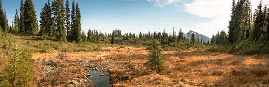
The view of the valley below

Anticipating a long drive from Nanaimo, our plan of attack included camping at the trailhead to give an early morning start. We left Nanaimo well after dark as I needed to tuck Hemingway into bed first. The four of us rendezvoused at Phil’s house before hitting the long road to Seward Junction. Our beta provided good directions to the trailhead. Though the road is in reasonable condition, we encountered several cross-ditches at the upper elevations. Twice the passengers vacated the car to give enough clearance to get through the ditches and up the steep sections of hill. Once, they even pushed so I could get enough power to get up the hill; damned standards! All told, the drive took about four hours, including the long (more than 40 kilometres) logging road. It may have been faster had we travelled in daylight; the drive includes multiple turns on logging roads, and a few times we nearly took incorrect spurs.

Queen Peak Vancouver Island, Hiking Lettington
A late setup by car-lamp and an evening beverage before bed.
Queen Peak, Vancouver Island Map and GPS Route
Queen Peak GPS Route and Map with photographs

Total Horizontal Distance: 6 km
Starting Elevation: 700 m
Maximum Elevation: 1639 m
Elevation Gain: 972 m
Time: 6 hours 20 minutes

 High up on the logging road, at the start of our hiking route at 720 metres, we set up camp under clear skies. The stars shone bright, outlining the black silhouettes of the distant peaks. We shared a few beers before heading to bed. Though I slept well, I would be remiss in my friend-duties if I left out one detail: we camped near a trickling stream that created a significant amount of noise all night long. Though I didn’t have an issue, several of the hikers found sleep difficult, and made several trips to … water the forest.

–Read the full report on Matthew’s blog: Boring Art, Boring Life

El Capitan — Trail Clearning toward Lomas

-Submitted by Matthew Lettington


Recently, the Island Mountain Ramblers purchased a piece of trail-clearing equipment with the help of a grant from the Federation of Mountain Clubs of British Columbia. The club members had a busy summer, and September 25th was the first chance for us to get out as a club and use it.

GPS Route and Map with Photographs

Total Horizontal Distance: 20.8 km
Starting Elevation: 208 m
Maximum Elevation: 1210 m
Total Elevation Gain: 1051 m
Total Time: 7h 5m

 There are a lot of trails in need of maintenance. For our first effort, we chose to clear the Lomas Lake trail. In the summer of 2014, Sherry Durford led a club trip to the lake, and we noted that the trail was slightly overgrown. At the time, we discussed the need for trail maintenance; this was the impetus for us to submit the application for the grant. Our plan was to clear the trail to a point right before the final creek, and then search for a route to the col between Mount Service and El Capitan.

Read the full report on Matthew Lettington’s Blog, Boring Art, Boring Life

Mount Moriarty

-Submitted by Dean Williams

8 hikers set froth from Labour Day Lake to summit Mount Moriarty. It wasn’t the best day out
but not too bad, some horizontal sleet at the top, but we had a bit of a view
for a short time.  It was sunny on the peak by the time we got back down
to the lake. 

East Sooke Coast Trail –Lifetime Achievement Objective–

–Submitted by Phil Dol
East Sooke Regional Park offers 50 kms of trails through forest, marsh and field a Challenging 10 km Coast Trail, Pocket beaches, rocky bays and tide pools for exploring and scuba diving and Spectacular views of the Strait of Juan de Fuca and Olympic Mountains. This would be my third hike following the Coastal Trail from Pike Road to Aylard Farm. We started by making arrangements the day before with Sooke Harbour Taxi to pick us up at the Aylard Farm parking lot and drop us at the Pike Road trail head. 

We departed Parksville at7:00am Saturday in the darkness of the early morning not knowing what type of weather we would encounter today. When we were about 20 minutes from the Aylard parking lot we contacted the dispatcher for Sooke Harbour Taxi to confirm that we would be ready at our pre-arranged time for pickup. 
The day started out cool and overcast with a blanket of fog over the ocean blocking our view of the Olympic Mountains. The trail is fairly easy to follow with a well trodden path through the forested sections and reflective markers over the rocky areas, recently they have added colour trail maps at the major trail junctions as well as the existing wooden directional signs.

 We stopped for lunch at the Cabin Point Trap Shack, normally I would sit on the rocks and enjoy watching the waves move in and out over the tidal pools, but today we sat under the protection of the trap shack roof overhang from the light drizzle that had started about an hour earlier. This area is were you will usually start to see people on the trail. Along they way to our next stop at Beechy Head the sun decided to come out. From Beechy Head we continued past the Petroglyphs at Alldridge Point and to our final stop at Creyke Point to enjoy watching the sunlight start to diminish over the ocean before returning to the parking lot at Aylard Farm.
Along the trail we enjoyed the rugged coastal terrain views of Vancouver Island, multiple Heron sighting, a few Seals having a nap on the rocks, numerous Sea Gulls and a very vocal Squirrel. The trail is well maintained with lots of ups and downs, but no major elevation gain, also there are a few spots along the way that drop down to sea level. In total we hiked 13.5 km and took 7 hours with lunch and a few picture breaks.

Mount Phillips via Arnica Lake

I’m using Island Alpine as a benchmark of mountaineering achievement, a checklist of mountains to summit. It mostly leads me to exciting adventures which I approach with anticipation, but every so often I find a hike where my expectations are low. Setting out to hike Mount Phillips in Strathcona Park is an example. In August 2013, I hiked the lengthy Phillips Ridge to the peak of Vancouver Island, The Golden Hinde. I assumed I would be hiking a well-booted trail through open terrain to a summit that many people regularly visit. The day would blow my expectations out to the water.

Mount Phillips, Strathcona Park, Vancouver Island, Map and GPS Route

GPS route with photographs in place

Total Distance: 29 km
Starting Elevation: 350 m
Maximum Elevation: 1722 m
Elevation Gain: 1900 m
Total Time: 9.5 hours

 Our new hiking tradition seems to be setting out well before dawn. On Sunday, October 18th, we set out from Phil’s house at 5:30 am, and arrived at the trailhead near the Nystar Mine not too long after sunrise. On the drive in we were mired in dense fog, but temperatures were warm, around 12 degrees, even before dawn. We were in for a cracker of a day!

-Read the full report on Matthew Lettington’s Blog: Boring Art, Boring Life

2015 Minnas Ridge

–Submitted By Dean Williams

 There were nine of us all told, and the weather was perfect with views down to the Olympic Mts,  Mt Baker, the coast range and of course Vancouver island.  No one was brave enough for a swim this year, but the water was looking a little murky in the bigger tarns. All in all a great fall outing with the club.

H’Kusam Mountain

–Submitted by Matthew Lettington
Read the full report on his blog, Boring Art, Boring Life

I’m the classic weekend warrior. I only have one day a week to get out and make mountaineering magic happen. Though there is a ridiculous number of opportunities on Vancouver Island for outdoor adventure, Phil and I are exhausting the climbs that are possible to do as day hikes.

H'kusam Mountain via Stow Creak Trail
Phil walking in the krumholtz on our way back from the summit. 

Already we are pushing far up-island. Many of our Sunday adventures require more than five hours of driving, including early 5 am departures from Nanaimo. The Prince of Whales Range is proving to be a great location for new hikes. On Sunday, October 4th, Phil hosted an Island Mountain Ramblers event, a hike up H’kusam Mountain. Four of us met and hiked this objective, and three of us made the summit!

H'Kusam Mountain Stow Creek Trail Map
H’Kusam Mountain via Stow Creek Trail Map

Total Horizontal Distance: 11.1 km

Starting Elevation: 700 m

Maximum Elevation: 1664 m
Elevation Gain: 1028 m

Time: 7 hours

There are several trails used to access this peak. Two of them form a portion of the trail used for the H’kusam Climb, an annual trail-running event hosted out of Seyward. We used the Stowe Creek Trail, accessed off the Stowe Creek Main Line. Driving north about 60 kilometres from Campbell River, turn right off the highway onto Timber Road and take the left fork. The Stowe Creek Main Line follows the route used for the H’kusam Climb and as such, some maps have the road marked as a trail. It’s definitely a road, but only a vehicle with high clearance and 4WD will be able to negotiate the crossditches and creek crossing to make it to the start of the trail. I left my Outback near the highway and hopped into Phil’s Jeep Liberty. The larger vehicle made it to the trailhead at 700 metres of elevation with little challenge…

Read the full report on his blog, Boring Art, Boring Life

Mackenzie Peak

–Submitted by Matthew Lettington
Read the full report on his blog: Boring Art, Boring Life

Highway 14 features some of the bushiest alpine routes on Vancouver Island. Phil Stone even mentions the region in his list of the Island’s best bushwhacks, though this particular route doesn’t make the list. Because the area is not protected by any special status, most of it has been logged. The regrowth is often dense and difficult to navigate, and in alpine regions the stunted trees are even denser – in some cases, wall-like.

Mackenzie Peak, Alberni-Valley Vancouver Island taken by Matthew Lettington
From Mackenzie Summit looking east towards Cats Ears, Tripple Peak and more.

The approach to Mackenzie Peak trailhead is easy. The route starts on Highway 4, about 58 kilometers from the orange bridge in Port Alberni. Look for a pullout on the right side of the road as you round a corner. The trail is on the left side (east) of the highway. We found a long orange ribbon hanging from a tree, marking the start of the trail. We parked on the side of the highway and started up the route just after 8:00 am on Sunday, September 27th. In anticipation of a long day, we didn’t push ourselves too hard.

Mackenzie Peak Map and GPS Route, Vancouver Island
Mackenzie Peak  Map and GPS Route with photographs 

Total Horizontal Distance: 11 km
Starting Elevation: 32 m
Maximum Elevation: 1417 m
Total Elevation Gain: 1449 m
Total Time: 10h 10 m

Read the full report on his blog: Boring Art, Boring Life

Mt Albert Edward with Youth

 –Submitted by Bil Derby

26 – 28 September 2015

We all know Mt. Albert Edward, most of us have been there (some many times), and, for all arguments sake, it is an easy summit to tuck under our belts. It was my first island summit in 2005 and the one that sparked my interest in mountaineering and the alpine that burns strong today. This past weekend I had the pleasure of introducing four Royal Canadian Air Cadets (shameless plug for the Air cadet program) aged 14 – 17 to Mt. Albert Edward.

This trip was their second with me, the first being Flores Island, and was their first island summit. It was also the successful completion of their respective Bronze and Silver level expeditions within the Duke of Edinburgh’s Award program, the cadets having planned and executed the trip on their own with only my supervision and advice on risk management.

We started from Raven Lodge early afternoon on Saturday and found ourselves at Circlet Lake at 17:30 after poking along through Whiskey Meadows, taking a few detours to see things, and stopping a few times to deal with tender feet, adjust packs, and offer encouragement in the form of food……they are teenagers after all.

Sunday was an amazing bluebird alpine day, all sun……and wind. The ascent to the ridge reminded tired legs of yesterday’s exertion and hinted at the exertion yet to come but the view from the first alpine plateau was reward enough and spirits remained high.

Reaching the main ridge line connecting Jutland and AE there was suddenly a clear understanding of the scale of the mountains.

Mount Albert Edward (left), Mount Regan (Right)

Lunch enroute, a bit of a snowball fight, and a long slug up the summit slope found us on top at lunch and notations made in the register. We were five of 17 to summit, not counting the five that were coming up as we were headed down.

Back at Circlet for supper and a debrief on the days experience and then, to my amazement, the teenagers went off to bed while the old guy stayed up and watched the stars drift by in a crystal clear sky.

Monday we came out via Murray Meadows, Kwai Lake, and the Battleship trail. Tired teenage legs conveyed tired teenage bodies relentlessly towards the truck….and food….did I mention they were teenagers.

All in all it was a fantastic trip with a fantastic group of kids. They enjoyed their trip and I enjoyed their enthusiasm, energy, and trust. Lessons were learned; I from them and them from me, and each of them came away with an little bit deeper understanding of their place in world, the value of wild places, and the accomplishment and confidence that comes from stepping out of their comfort zone.

Planning, in the warm light of accomplishment, is underway for their next adventure. Hopefully they humour me once again and let me tag along; it keeps the mind young when you can share time with youth.

Bil Derby
Captain
205 Collishaw RCACS (Nanaimo)
Canadian Cadet Organization

Cruikshank Canyon

— Submitted by John Young
The day turned out much better than we’d expected. It was raining on the
drive up, but we just had some light mist on the hike, and by the end of it,
the sun actually came out. Although the views weren’t there (couldn’t see
Cruikshank Canyon at all!), the fall colours were wonderful, and the many
mushrooms were dazzling. A lovely seven hour jaunt around Paradise!