–Submitted by Rod Szasz
–Photographs take by Maryann Wiggle

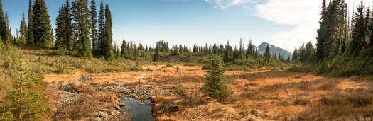
A group of six members ascended and climbed both peaks of Gemini Mountain, a mountain totally within the Nanaimo River watershed. The goal was to reprise a route taken the week before in foggy, drizzle where nothing could be seen. It was expected that views would be good and they did not disappoint .
The group comprised, Rod Szasz, Dean Williams, Rick Bronson, Lisa Bee, Deborah Blum and Maryanne Wiggle. Taking the traditional access to Green Mountain we ascended the road to the pass between the two peaks and parked. We entered beautiful first growth forest immediately with the goal of an ascending traverse to the notch between the North and South peaks of Gemini. The notch has some good Krumholz features and is relatively flat once it is reached about 300 metres above our starting place. From here it was more or less open and nice walking. After a more steep ascent we reached the open South summit and signed into the summit register we established in a cairn the week before. The summit and the cairn are on the northern boundary of the Haley Lake Marmot reserve. We did not enter the reserve.
From the South Summit we descended and then after climbing over a bump in the middle of the notch we ascended directly through good forest and elk trails the main and more frequented North Summit. There is no cairn here but two rocks on the highest point, a boulder on the summit. The South summit has had some trees cut on the south side to remediate the environment for marmots. We saw some older marmot dens, but nothing recent. Both North and South summits are broad and expansive with bluff bands breaking away offering unrestricted views.

This is only a moderate hike, but there is no trail and only a little flagging leading to the Northern, closest peak of the twins. This flagging is old and disappears rather soon, you cannot rely upon it. The Northern peak is 1518 metres and Southern summit at 1528 metres is only about 10 metres short of Mt. Whymper. People climbing this peak should be prepared and have experience with route finding. Use of GPS, map and compass in proper combination is de rigour (and know that a GPS can never totally substitute map and compass).
Highlights of the trip were the views, numerous mushroom species seemingly everywhere, elk sign, groves of mountain hemlock and fairy-like glens, open forest and good conversation. We saw much elk sign, some low deer rubbings and some older bear scat. Total time hiking was only 4 hours at a moderate pace. Total up and down, around 500 metres.

The area of Nanaimo Watershed and its peaks used to be frequented very often by Ramblers in the past. Changes of land ownership and active logging have lead to restriction of access to limit liability and vandalism. There was no evidence of anyone frequenting this area and the South Peak is really bereft of any human sign- my guess would be that less than 50 people summit the North Summit and around 10-20 for the South Summit on any given year. The roads are open to hunters and hikers from early September to the middle of December for hunting season and hikers can also take advantage of this to reach the high areas as well. Although hunters were passed in their vehicles we have never encountered any once in the old-growth forest. As a matter of prudence, if we see hunters where we are hiking we usually stop and offer then a greeting and let them know where we are planning to be.